![[RR 22]](transpo/rr22.png)
![[RR 222]](transpo/rr222.png)
![[RR 622]](transpo/rr622.png)
![[RR 56]](transpo/rr65.png)
![[RR 65]](transpo/rr65map.png)
| Highway | Duration | Start | Terminus | Length (km) |
|---|---|---|---|---|
| CR 22 | 193?-195? | Sawmill Rd., Brant County line | Niagara Region line east of Binbrook | 24 |
| CR/RR 22 | 195?-1979 | Wilson St. (ON 2/53) and ON 52 west of Duff's Corners | Niagara Region line east of Binbrook | 30 |
| RR 222 | 1979-2005 | Wilson St. (historic ON 2/53) and RR 52 (ON 52) west of Duff's Corners | Glancaster Rd. west of Mount Hope | 11 |
| RR 622 | Glancaster Rd. west of Mount Hope | Niagara Region line east of Binbrook | 19 | |
| RR 65 | 2005- | RR 52 and Brant County CR 22, Brant County line | Niagara Region line east of Binbrook | 24 |
Highway 65 is an east-west road skirting greater Hamilton's rural southern outskirts. It grazes the vicinity of Hamilton's airport in Mount Hope, and also serves the community of Binbrook. East of municipal boundaries, the road continues in the Niagara Region with the same number.
Both the configuration and number of this highway changed when Hamilton restructured its municipal roads in the 2000s. Part of its former course is now RR 52.
At present, Highway 65 is the only one of Hamilton's numbered regional roads that was never an Ontario provincial highway. It's unclear when exactly it first bore a number, but local maps show it as Wentworth County CR 22 by 1940. The routing itself is an order of magnitude older: Its east-west course follows concession lines of the early nineteenth century, with jogs caused by surveying inconsistencies between different townships.
The original configuration of CR 22 showed the road ending at the Brant County line. The road was later extended to take an L-shaped turn west of Carluke, continuing north to Highways 2, 52, and 53 west of Duff's Corners.
As such, the highway has seen a number of changes:
![[RR 65]](transpo/rr65y.png)
![[RR 222 and 622 division]](transpo/rr65split.png)
All photos are by the author, 2022-2025:
![[RR 65 photo]](transpo/rr65-25.jpg)
Regional Road 65, as seen from its terminus on the Niagara Region line.
![[RR 65 photo]](transpo/rr65-25a.jpg)
![[RR 65 photo]](transpo/rr65-25b.jpg)
Nearby, a bypassed stub of pavement exists from where a curve was straightened out by the early 1970s. A bit of yellow paint is still visible on the centre line.
![[Home]](home.gif) The Network
The Network![[Back]](back.gif) Hamilton
Hamilton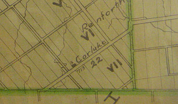