![[ON 53]](transpo/on53old.png)
![[ON 53]](transpo/on53.png)
![[ON 53]](transpo/on53map.png)
| Highway | Duration | Start | Terminus | Length (km) |
|---|---|---|---|---|
| ON 53 | 1937-1997 | Brant County line west of Alberton | ON 20, Elfrida | 28 |
Highway 53 is a former east-west highway that served as a connecting link between Ontario Highways 2 and 20, skirting urban Hamilton's south edge and bypassing its downtown core. Most of 53's course ran either parallel to or concurrent with Highway 2, with only the easternmost leg forking away to any significant degree.
Until the 1990s, this road was a significant carrier of intercity traffic destined for the Hamilton Mountain from Brantford, Woodstock, and points further west. With the completion of the 403 and Lincoln M. Alexander Parkway, however, its importance was greatly reduced. In 1997, the entire length of Ontario Highway 53 in Oxford, Brant, and Hamilton-Wentworth was excised from the provincial ledgers and converted into a patchwork of local roads.
As with Highway 2, Highway 53's course in greater Hamilton presently languishes without an identifying number. A variety of names have been imposed for different segments: Wilson Street, Garner Road, and Rymal Road. Outside of Hamilton, the situation is scarcely any better: The route is very difficult to follow thanks to the lack of any signage in Brantford, lackadaisical signage in Brant County, and a confusing mismatch of county road designations: Oxford CR 55, Brant CR 53, and Brant CR 2/53 with a West Virginia-style fraction!
Highway 53 follows the concession lines of the late eighteenth and nineteenth centuries, with the east portion additionally following the Barton-Glanford and Saltfleet-Binbrook township lines. Despite its simple routing upon pre-existing infrastructure, Highway 53 has a complicated history.
Aside from its concurrency with ON 2, the first portion of ON 53's course to be made a numbered highway were the 7 kilometres west of its intersection with Upper Gage Avenue. These formed part of the original alignment of ON 20 in 1930.
In 1932, Highway 20 was realigned to its present route along what is now Centennial Parkway. This caused the old highway to be renumbered as ON 20A.
![[ON 20A]](transpo/on20ax-37dho.jpg)
![[ON 53]](transpo/on53x-38dho.jpg)
(DHO, 1937, 1938)
Shortly afterwards, the province decided to add a spur to ON 20A linking it westward to Highway 2. Since 20A was now a multi-pronged web of roads all bearing the same number, the province chose to rectify the confusion in 1937 by reconstituting the 20A spurs with new numbers. The east-west portions became part of ON 53, while the north-south portions became ON 55.
Prior to 1937, ON 53 already existed as a highway west of Hamilton in Oxford and Brant counties. To tie the two independent segments of 53 together, the DHO added a 21-kilometre concurrency to Highway 2 between Brantford and Duffs Corners.
Surprisingly, ON 53 experienced no realignments or changes in its entire sixty-year history other than widening and minor curve adjustment.
![[Former ON 53 photo]](transpo/rr20-25b.jpg)
Highway 53's east terminus. Despite intersecting two other former provincial highways with intact numbers, 53's course earns mention only as "Rymal Road."
![[Former ON 53 photo]](transpo/on53-25.jpg)
An underpass carries former ON 53 under the new alignment of ON 6 near Duff's Corners. Privacy walls shield the older road from the eyes of any motorists travelling overhead, seemingly in shame.
![[Home]](home.gif) The Network
The Network![[Back]](back.gif) Hamilton
Hamilton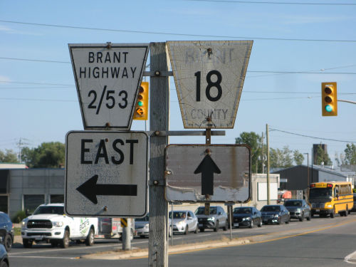