![[ON 20]](transpo/on20old.png)
![[ON 20]](transpo/on20.png)
![[RR 20]](transpo/rr20.png)
![[RR 20]](transpo/rr20map.png)
| Highway | Duration | Start | Terminus | Length (km) |
|---|---|---|---|---|
| ON 20 | 1930-1932 | Main St. (ON 8), downtown Hamilton | Lincoln County line east of Elfrida | 22 |
| ON 20 | 1932-1964 | Burlington Canal, Hamilton Beach | Lincoln County line east of Elfrida | 22 |
| ON 20 | 1964-1998 | QEW north of Stoney Creek | Lincoln County/Niagara Region line east of Elfrida | 15 |
| RR 20 | 1998- | QEW north of Stoney Creek | Niagara Region line east of Elfrida | 15 |
Highway 20 is a road serving Stoney Creek and the northeast extremities of urban Hamilton, following an L-shaped course from the Queen Elizabeth Way south to Elfrida, then bearing east towards the Niagara Region, where it continues with the same number. The north segment is signed as the Centennial Parkway. The Niagara portion leads directly to the approach for the Rainbow Bridge and the U.S. Border.
Part of Highway 20 is signed as north-south, and part is signed as east-west...which makes sense given its irregular alignment, but which also makes navigation absolutely maddening.
Hamilton RR 20 originated in 1930 as an Ontario provincial highway; the first of several "second wave" highways commissioned that decade to flesh out gaps in the map. Its original configuration differed wildly from what it later became, with a route along the following present-day streets and roads:
This routing made use entirely of pre-existing infrastructure from the nineteenth century or earlier. The southern portion also neatly followed the township lines separating Barton from Glanford and Saltfleet from Binbrook.
Almost immediately after taking this highway on, the Department of Highways of Ontario initiated plans for realignments and improvements, starting with the construction of a rock cut through the Niagara Escarpment at Stoney Creek. Over the next ten decades, the following changes commenced:
![[RR 20]](transpo/rr20y.png)
![[ON 20 map]](transpo/on20x-60ase.jpg)
(Army Survey Establishment, 1960)
![[ON 20A]](transpo/on20a.png)
![[ON 20A]](transpo/on20a-map.png)
| Highway | Duration | Start | Terminus | Length (km) |
|---|---|---|---|---|
| ON 20A | 1932-1937 | ON 20, Elfrida | Main St. (ON 8), downtown Hamilton | 16 |
| ON 20A (spur) | 1933?-1937 | Upper Gage Ave. (ON 20A) west of Hannon | Wilson St. (ON 2), Duffs Corners | 14 |
| ON 20A | 1938?-1946 | ON 20, Hamilton Beach | Main St. (ON 8), Hamilton | 5 |
| ON 20A | 1946-1951 | ON 20, Hamilton Beach | Main St. (ON 8), Hamilton | 5 |
Four alternate ("A") spurs of Ontario Highway 20 existed in Hamilton in the highway's early decades...and confusingly, two of them existed at the same time as competing prongs of the same fork!
The first incarnation of ON 20A was simply the original 1930 alignment of Highway 20, kept on as a supplementary route.
Soon afterwards, a secondary ON 20A spur connected Highways 20 and 20A to Highway 2 along Rymal Road and Garner Road. The 1934 Ontario highway map was the first to imply an provincial highway on this route; the 1937 map made it explicit.
Later the same year, the province chose to rectify the confusion by reconstituting the 20A spurs with new numbers. The east-west portions became part of ON 53, while the north-south portions became ON 55.
The third incarnation of ON 20A ran along Burlington Street, Beach Road, and Ottawa Street via the Windermere cutoff from Highway 20's Hamilton Beach extension, ending at Highway 8. It's ambiguous when this spur was commissioned or signed: Provincial maps imply a highway connection on Beach Road as early as the 1920s(!), but no number appears until 1946.
In 1946 or 1947, the south portion of Highway 20A was shifted west to follow Kenilworth Avenue instead of Ottawa Street. This was the final alignment of the road.
After 1951, ON 20A in Hamilton vanished from the maps. Most of the route would later be repurposed as an extension of ON 55; though this too would soon expire.
All photos are by the author, 2022-2025:
![[ON 20 photo]](transpo/on20-25.jpg)
![[ON 20 photo]](transpo/on20-25a.jpg)
Beach Road crosses the Burlington Canal over this lift bridge, the last in a long line of movable structures that have stood on the site since the nineteenth century. The current bridge dates to 1962 and very briefly carried ON 20 before the highway was truncated to its current terminus.
The second photo shows the lift span in the "up" position, with the QEW's Burlington Bay Skyway Bridge in the background.
![[RR 20 photo]](transpo/rr20-25c.jpg)
Climbing the Niagara Escarpment through ON 20's Stoney Creek Cut.
![[RR 20 photo]](transpo/rr20-25b.jpg)
Decisions, decisions. This redundant cluster of signs appears at RR 20's eastward turn.
![[RR 20 photo]](transpo/rr20-25d.jpg)
![[RR 20 photo]](transpo/rr20-25e.jpg)
Near the regional boundary lies a section of highway that was bypassed by 1960 (see E above). This includes a 300-metre curve segment that has been closed to traffic, making this the longest stretch of abandoned highway in Hamilton! Original pavement is intact, while a conspicuous guardrail blocks access from the west end.
![[RR 20 photo]](transpo/rr20-25a.jpg)
Hamilton Regional Road 20, as seen from its terminus at the Niagara Region border.
![[Home]](home.gif) The Network
The Network![[Back]](back.gif) Hamilton
Hamilton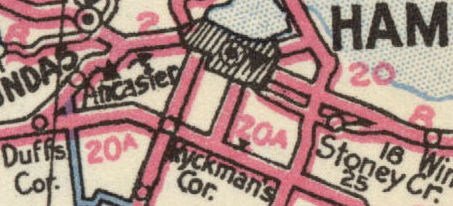