![[ON 8]](transpo/on8old.png)
![[ON 8]](transpo/on8.png)
![[RR 8]](transpo/rr8.png)
![[ON 8 & RR 8]](transpo/on8map.png)
ON 8 in blue, RR 8 in purple.
| Highway | Duration | Start | Terminus | Length (km) |
|---|---|---|---|---|
| ON 8 | 1925-1973 | Waterloo County line west of Sheffield | Lincoln County line east of Winona | 55 |
| ON 8 | 1973-1997 | Waterloo Region line west of Sheffield | Niagara Region line east of Winona | 54 |
| ON 8 | 1997- | Waterloo Region line west of Sheffield | ON 5, Peters Corners | 16 |
| RR 8 | ON 5, Peters Corners | Niagara Region line east of Winona | 39 |
Highway 8 is the main east-west surface road in the region, serving traffic in Hamilton's downtown core as well as Dundas and Stoney Creek. It's one of Ontario's premiere provincial numbered roads, with a lineage back to 1925. The routing has changed surprisingly little over the intervening century, although like Highway 5, the route has been divided between provincial and regional portions.
Outside of greater Hamilton, Highway 8 extends across the width of southern Ontario clear to the Lake Huron shore. Its west terminus is Goderich, in Huron County. The eastward road originally extended to Niagara Falls, but has been truncated. In the Niagara Region, the highway continues as RR 81 as "8" was used to designate a separate road.
Like Hamilton's other single-digit highways, Highway 8 originated in Ontario's highway route numbering plan of 1925. The road itself is even older, being routed over pre-existing infrastructure from the late eighteenth and nineteenth century, and taken under the province's control as the Hamilton-Queenston Highway and Goderich-Hamilton Road in 1918-20. Several portions of the road follow concession lines; however, the west portion takes a diagonal tack against the survey grid, while King Street and the section closest to the Niagara border follow a pre-colonial footpath paralleling the escarpment.
Over the years, the following changes and adjustments have been made:
![[ON 8 & RR 8]](transpo/on8y.png)
![[ON 8]](transpo/on8x-64dho.jpg)
![[ON 8]](transpo/on8x-67dho.jpg)
(DHO, 1964, 1967)
![[ON 8A]](transpo/on8a.png)
![[ON 8A]](transpo/on8a-map.png)
| Highway | Duration | Start | Terminus | Length (km) |
|---|---|---|---|---|
| ON 8A | 1925-1927 | ON 8, Stoney Creek | Burlington Canal, Hamilton Beach | 10 |
| ON 8A | 1927-1932 | ON 8, Stoney Creek | Burlington Canal, Hamilton Beach | 9 |
In Ontario Highway 8's earliest years, an alternate ("A") spur connected Stoney Creek to Burlington via Hamilton Beach.
The original routing followed Lake Avenue with a meandering course through the Stoney Creek valley. In about 1927, this was replaced with a newly-constructed course further west along what is now RR 20 and Centennial Drive. Both courses passed through what is now Confederation Park, which is closed to through traffic.
Some maps show a secondary spur connecting Highway 8A to downtown Hamilton via either Barton Street or Ottawa Avenue; however, this was unnumbered.
In 1932, ON 8A disappeared from the maps as the road was incorporated into an extension of ON 20.
![[ON 102]](transpo/on102.png)
![[ON 102]](transpo/on102map.png)
| Highway | Duration | Start | Terminus | Length (km) |
|---|---|---|---|---|
| ON 102 | 1947-1964 | Main St. (ON 8), Dundas | Main St. W. (ON 8), McMaster University, Hamilton | 3 |
Highway 102 or Cootes Drive was the first "modern" four-lane divided highway in Hamilton and Wentworth County, serving as a bypass of Osler Drive on the east edge of Dundas.
This wide, smooth, high-capacity highway was undoubtedly conceived as a new alignment of ON 8, and opened to traffic in 1937. Strangely, however, the Department of Highways kept ON 8 on its original routing and let the bypass languish without a number until 1947, when it was assigned the designation ON 102. The road was first labelled on highway maps in 1955.
Highway 102's time in the spotlight was brief: In 1964 the DHO removed ON 102 from its inventory, demoting the bypass to city streets. By 1973, the route had assumed the designation of County Road 41. ON 8 remained in place on Osler Drive for the remainder of its existence as a provincial highway.
Not until the late 1990s was Highway 8 finally realigned onto Cootes Drive...and by that point Highway 8 was a Regional Road, making the maintenance and ownership distinctions moot.
All photos are by the author, 2020-2025:
![[RR 8 photo]](transpo/rr8-25e.jpg)
Welcome to Hamilton! This sign greets visitors as they begin their journey on RR 8 at the Niagara Region line.
![[RR 8 photo]](transpo/rr8-23.jpg)
Highway 8 at Wentworth Street. RR 8 is posted frequently within the core of the city, but somewhat irregularly.
![[RR 8 photo]](transpo/rr8-25f.jpg)
![[RR 8 photo]](transpo/rr8-25c.jpg)
The arched entrance to downtown Hamilton on King Street at Wellington (on Open Streets day, when cyclists rule the road). Heavy truck traffic is diverted away from the highway on an alternate route.
![[RR 8 photo]](transpo/rr8-25.jpg)
![[RR 8 photo]](transpo/rr8-25a.jpg)
Despite being conceived as a bypass for Highway 8, it took more than 60 years before Cootes Drive actually began to bear that number. A bridge on this segment contains an abutment prominently dated 1975.
![[ON 8 photo]](transpo/rr8-25g.jpg)
A spectacular view of the escarpment from Regional Road 8 facing east, descending into Dundas.
![[ON 8 photo]](transpo/on8-25.jpg)
Ontario Provincial Highway 8 picks up at Peters Corners (also the dividing point of ON/RR 5), and continues into the Waterloo Region before being broken again. *sigh*
![[ON 102 photo]](transpo/on102-20.jpg)
Highway 102 lives! Well, sort of. About seven years after the Cootes Drive "diversion" was struck from the provincial highway system in 1964, the number was recycled for an unrelated highway in Thunder Bay, and that's where this picture was taken.
![[Home]](home.gif) The Network
The Network![[Back]](back.gif) Hamilton
Hamilton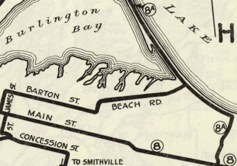