![[Alternate WV 3]](transpo/wv3alt.png)
![[WV 107]](transpo/wv107.png)
![[WV 107]](transpo/wv107smap.png)
| Highway | Start | Terminus | Length (km) |
|---|---|---|---|
| WV 107 | WV 20, downtown Hinton | WV 3, Bellepoint | 3 |
| Alternate WV 3 | WV 3 west of Hinton | WV 3, Bellepoint | 6 |
West Virginia Route 107 is a short highway running through the city of Hinton, entirely within corporate limits.
Hinton as we know it today was formed through the 1927 amalgamation of three distinct communities: The original City of Hinton, founded in 1873 on a bluff overlooking the New River; Avis, located below the bluff to the south; and Bellepoint, at the mouth of the Greenbrier River three kilometres upstream. WV 107 literally bridges the three communities together, connecting WV 20 to WV 3 on the east side of the New River. It also has an interesting history, being both an original alignment and longtime alternate alignment of the latter road.
Hinton was founded in 1873, spurred by the construction of the C&O Railroad through the New and Greenbrier River valleys. With the establishment of the new city came the construction of a street grid, and by the 1880s the future course of WV 107 (including the first bridge over the Greenbrier River) was in place.
![[WV 21 map]](transpo/wv21x-22src.jpg)
(WV State Road Commission, 1922)
West Virginia established a numbered highway system in 1922. Summers County was crossed by WV 21, entering downtown Hinton from the west, then bearing south through Avis and Bellepoint. Traffic through Avis was placed on one-way splits, evidenced in an early 1930s map.
WV 21 was renumbered WV 3 in 1931. The highway had also undergone adjustment, approaching the New River through the Beech Run valley, tacking north a kilometre to the only bridge crossing, then tacking south again. Not only did this take through travellers out of their way, but by the 1950s the downtown route was making its weaknesses known:
![[WV 3 Alternate]](transpo/wv3special.png)
In 1954 the Bellepoint Bridge opened, bypassing all of the above liabilites. By 1955, WV 3 had been officially moved to the new route. To provide an alternate route and to encourage travellers to patronize local businesses, however, the state elected to retain the old alignment as Alternate 3.
![[WV 20]](transpo/wv20x-c75wvdh.png)
![[WV 20]](transpo/wv20x-04wvdot.png)
(WVDH/WVDOT, c. 1975 & 2004)
In the 1970s the West Virginia Department of Highways started rationalizing alternate and discontinuous highway routings, assigning many of them new three-digit numbers. By 1982, the trend had come to Hinton: Alternate 3 was replaced by the newly-minted route WV 107 between Temple Street and Bellepoint. The remainder became WV 20, restoring that highway's pre-1955 routing. The change enabled WV 107 to be posted as a north-south road, reflecting its actual geographical orientation rather than WV 3's overarching east-west compass.
The number "107" is arbitrary, with no particular significance. Sequential patterns can sometimes be seen with West Virginia route numbers, but forty years would pass before it was joined by WV 108.
A full list of known adjustments follows:
![[WV 107]](transpo/wv107sy.png)
All photos by the author, 2013 (except as otherwise noted):
![[WV 20 photo]](transpo/wv20-hinton64yearbook.jpg)
A: WV 107's direct predecessor, Alternate 3, functioned as an east-west business route serving downtown Hinton and as a connector for concurrent north-south traffic on WV 20. Here's a picture of 1948-spec signs for both highways, facing traffic off the bridge at 2nd Avenue in either 1963 or 1964. Today, this point forms 107's north terminus. (Hinton High School yearbook, 1964.)
West Virginia's style of signing alternate routes in the 1950s and 1960s was a bit unusual. Rather than giving routes an "Alt" plaque or a letter suffix like 3A, the state instead added the word "ALTERNATE" in small letters to the top of the number sign itself.
![[WV 107 photo]](transpo/wv107-hinton13a.jpg)
![[WV 107 photo]](transpo/wv107-hinton13.jpg)
B: The north end of WV 107 flanks the block of the Summers County Courthouse, an ornate Victorian structure dating to 1876. Its most distinctive exterior feature are its six pointed towers, resembling turrets, added to the hitherto-rectangular building in an 1898 renovation. A historical marker stands in front, giving a simplistic blurb that would probably be phrased differently if it were written today.
![[WV 107 photo]](transpo/wv107-hinton13b.jpg)
West Virginia was founded during the Civil War as a Union state, whose entire point, purpose, and predilection for existence was to reject the premise of the Confederate States of America.
Nauseatingly, this point is completely ignored in Summers County, where an actual memorial to treasonous secessionists stands in a traffic island near the courthouse grounds. Hinton's monument dates to 1914, and was part of a concerted monument-building effort by Sons of Confederate Veterans with an obvious objective: To control the narrative in a border area and reassert the dominance of ex-Confederates over the Black populations they had once enslaved, all while implying governmental endorsement of their cause. This included spinning a romanticized fabrication of the Confederacy and its supporters as "heroes who fought and died for a lost cause" (verbatim quote from the monument), rather than as the instigators of slavery, war, white-supremacist terrorism, and destruction that they actually were.
![[WV 107 photo]](transpo/wv107-hinton13d.jpg)
![[WV 107 photo]](transpo/wv107-hinton13e.jpg)
C: Downtown Hinton is perched on a bluff above the New River, overlooking the community of Avis. Three years after the communities were amalgamated in 1927, a concrete arch bridge was constructed to carry traffic between the two, bypassing a grade crossing and steep hillside. The Avis Overhead Bridge was unusual (and terrifying) for its curved south approach, oriented in line with Avis' Pleasant Street thoroughfare. Over the years, no fewer than five highways crossed over its span: WV 21, WV 3, WV 20, Alternate 3, and WV 107.
In 2003 a replacement bridge opened, and this old bridge was closed and barricaded to vehicular traffic. It remained open to pedestrians for a decade afterward, then was fenced off with foreboding "No Trespassing" signage; likely for liability reasons relating to its deteriorating condition. It's had a grave position on the Endangered Structures list ever since.
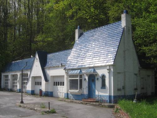
![[WV 107 photo]](transpo/wv107-hinton13c.jpg)
The 2003 closure of the Avis Overhead Bridge also resulted in the bypassing of some auto service facilities clustered around its span, including this former Pure and 76 gas station with a blue tile roof. The Pure Oil Company was famous for its consistent architecture, and stations like these were a 1940s modernization of the ornate 1930s cottages (as seen in Bramwell) that came before. I've seen identical buildings as far afield as Wisconsin.
![[WV 107 store]](artifacts/kro-wvhinton08.jpg)
D: After enduring a one-way split in Avis, WV 107 follows the shore of the New River upstream to Bellepoint on Stokes Drive. It passes by Hinton's only shopping centre, anchored by this Kroger Superstore which opened in 1979. The highway crosses the Greenbrier River shortly beyond, and terminates at the present-day alignment of WV 3.
![[WV 107]](transpo/wv107sfract.png)
Given WV 107's brief history, short length, and encapsulation by Hinton's municipal boundaries (and therefore street maintenance), it's surprising that there are any "107/nn" spur roads at all. Both are stubs left behind by the construction of the current Avis-Hinton bridge in 2003, and neither are signed as county roads in the field.
| Road | Names | Start | Terminus | Length (km) | Notes |
|---|---|---|---|---|---|
| 107/1 | Pleasant St. | WV 107, Hinton | WV 107, Hinton | insignificant | Former alignment of WV 3, WV Alt 3, and WV 107. Bridge closed. |
| 107/2 | Washington St., Main St. | CR 107/1, Hinton | WV 107, Hinton | insignificant | Former alignment of WV 3, WV Alt 3, and WV 107 southbound. |
![[Home]](home.gif) The Network
The Network![[Back]](back.gif) Summers County
Summers County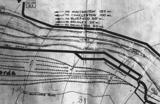