![[WV 12]](transpo/wv12.png)
![[WV 12]](transpo/wv12a.png)
![[WV 12]](transpo/wv12smap.png)
| Highway | Start | Terminus | Length (km) |
|---|---|---|---|
| WV 12 | Monroe County line near Indian Mills | Greenbrier County line, Glenray | 38 |
| WV 12 (original) | Monroe County line near Indian Mills | WV 3 east of Bellepoint | 15 |
WV 12 is a north-south highway that grazes Summers County's eastern edge, running through the Bradshaw Creek, Spruce Run, and Greenbrier River valleys.
In the context of the state's highway network, WV 12 functions as a connector between Monroe, Summers, and Greenbrier counties, servicing Red Sulphur Springs and offering a parallel detour to US 219. It also once reached Mercer County via a southwestern extension, now WV 112.
In Summers County, over 60% of this route is a concurrency with WV 3. Large portions of its course are level, but the highway is interrupted by mountainous segments near Forest Hill and Hilldale...both of which are exactly what they say on the tin!
WV 12 is a later addition to the state's repertoire of roads; one of a handful of highways commissioned in the 1940s to flesh out gaps in the highway map. As usual, the infrastructure of the road predates the highway system itself, and the entire route in Summers County was in place on maps by the second decade of the twentieth century.
![[WV 21 map]](transpo/wv21x-22src.jpg)
(WV State Road Commission, 1922)
WV 21 was commissioned in 1922, following the path of the Greenbrier River. The local segments of WV 21 were renumbered as WV 3 in 1931.
Two years later, the West Virginia county route system debuted. Summers County's network of minor roads were rounded up and assigned numbers, with the road running south from WV 3 through Forest Hill becoming County Route 21.
![[CR 21 map]](transpo/cr21x-35src.png)
![[WV 12 map]](transpo/wv12x-46src.png)
(WV SRC, 1935 & 1946)
In 1942, the state added a new highway to connect Red Sulphur Springs in Monroe County to Hinton and Peterstown: WV 12. It followed the pre-existing route of CR 21 in Summers County, diverging in the last two kilometres to connect to Monroe over CR 21/2. The upgrade in status brought with it improvements; namely widening, paving, and the bypassing of several curves in Forest Hill.
Initially, WV 12 ended east of Hinton at its intersection with WV 3. By 1946, however, the highway had been extended north to Greenbrier County via a concurrency. Route 12 was also extended on its south end, bearing west from Peterstown into Mercer County via a concurrency with US 219 that actually left the state and re-entered it!
WV 12 has seen almost no alignment changes in Summers County in the eight decades since:
![[WV 12]](transpo/wv12sy.png)
Since 1996, the segment of WV 12 south of Forest Hill has been signed as part of the Farm Heritage Road Byway. WV 122 is also part of this special tourist route.
![[WV 12 photo]](transpo/wv12-summers-postcard.jpg)
A colour postcard photo of WV 12 in the 1950s or 1960s, facing "north" (actually west) at the Summers-Monroe county line. Note the white central lane striping, the white post, and the white guide sign giving the names of both counties. These elements were normal at the time and permitted in the MUTCD prior to 1971, although West Virginia began to transition to green guide signs in the 1960s.
The alignment, grading, and curvature of this section of road are identical today. However, the scene itself now looks vastly different due to thick tree overgrowth.
![[WV 12]](transpo/wv12sfract.png)
West Virginia's fractional numbers have an uncanny knack for revealing the 1930s-era past. Few of the roads that branch out from WV 12 in Summers County actually bear "12/nn" road numbers: Most instead have the format of 3/nn or 21/nn, owing to its concurrency with WV 3 and prehistory as CR 21.
Over half the "12/nn" roads that do exist are located in the Madam Creek and Jumping Branch watersheds, far away from WV 12. This is because of a separate CR 12 that existed in the 1930s. CR 12 was renumbered as "3/21" after the 1940s to avoid number duplication, yet its fractional "children" live on.
| Road | Names | Start | Terminus | Length (km) | Notes |
|---|---|---|---|---|---|
| 12/1 | Broomstraw Ridge Rd. | CR 3/21 (former CR 12) near Jumping Branch | CR 3/1 north of Jumping Branch | 3 | Intersected CR 12, not WV 12 |
| 12/2 | Madams Creek Rd. | CR 3/21 (former CR 12) west of Brooklin | CR 3/1 near Raleigh County line | 8 | Intersected CR 12, not WV 12 |
| 12/3 | Davis Rd. | CR 3/21 (former CR 12), Brooklin | CR 12/6 near Brooklin | insignificant | Intersected CR 12, not WV 12 |
| 12/4 | Bigony Dr. | CR 3/21 (former CR 12) west of Brooklin | dead end | insignificant | Intersected CR 12, not WV 12. Missigned as 27/6. |
| 12/5 | Marie Rd. | WV 12, Forest Hill | CR 17, Marie | 3 | Formerly CR 20. West leg is a former alignment of CR 21, WV 12's predecessor road. |
| 12/6 | Moss Dr. | CR 12/3 near Brooklin | dead end | insignificant | Intersected a child road of CR 12, not WV 12 |
| 12/7 | Old Schoolhouse Rd. | WV 12, Forest Hill | WV 12, Forest Hill | insignificant | Former alignment of CR 21, WV 12's predecessor road. |
![[Continue to WV 12 in Monroe & Giles County]](transpo/continue-wv12mg2.png)
![[Home]](home.gif) The Network
The Network![[Back]](back.gif) Summers County
Summers County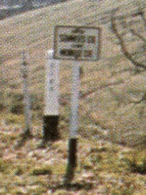