![[WV 24]](transpo/wv24.png)
![[US 219]](transpo/us219a.png)
![[US 460]](transpo/us460.png)
![[US 460]](transpo/us460a.png)
![[US 460]](transpo/us460map.png)
| Highway | Start | Terminus | Length (km) |
|---|---|---|---|
| US 460 (current alignment) | Tazewell County, Virginia state line south of Bluefield | Giles County, Virginia state line, Glen Lyn | 43 |
| US 460 (old alignment) | Tazewell County, Virginia state line, Bluefield | Giles County, Virginia state line, Glen Lyn | 46 |
| US 219 (historic) | US 19, Princeton | Giles County, Virginia state line, Glen Lyn | 26 |
WV 24, US 219, and US 460 are three highways whose history in Mercer County is quite literally entwined.
WV 24 was the first, and it appeared in the State Road Commission's original highway plan of 1922 as a road that started in Princeton and worked its way east. Though Route 24 passed out of the state at Glen Lyn, it actually re-entered West Virginia at Peterstown and functioned as a connection between Mercer County and Lewisburg, Marlinton, and points further northeast:
![[US 219-460 map]](transpo/us219x-22src.jpg)
(WV State Road Commission, 1922)
In 1926, the U.S. highway system was established. According to the numbering conventions of the AASHO, 3-digit highways function as spur roads of 2-digit "parents:" Ergo, US 219 was the second spur highway of US 19. In 1926, however, US 219 didn't extend south of Maryland, and it didn't actually touch US 19!
In 1934, US 219 was extended south through West Virginia, replacing WV 24 in its entirety and connecting with US 19 in Princeton as though it were always meant to be:
![[US 219-460 map]](transpo/us219x-46src.jpg)
(WV State Road Commission, 1946)
The AASHO weren't quite done redrawing the highway map, though. In 1946 the organization took US 460, a short highway that connected to US 60 in Virginia's Tidewater region, and extended it all the way west to Missouri. In the process, Mercer County got a new highway to play with!
US 460 was originally a completely redundant highway in Mercer County, running as a concurrency with US 219 from Glen Lyn to Princeton and US 19 from Princeton to Bluefield. Soon, however, it emerged as the more important transportation link, connecting Mercer County to Blacksburg and Roanoke to the east and such far-flung locales as St. Louis and Los Angeles (via US 66) to the west. US 460 would be prioritized for all highway widenings and improvements from this point forward.
In 1965, U.S. President Johnson initiated the Appalachian Development Highway System as a Great Society program to alleviate poverty through economic development and break down the rural isolation that suffocated the region. West Virginia at the time was inhabited by a populace and government that recognized the collective societal benefits of public infrastructure as a Good Thing, so the project got the go-ahead.
In the 1970s, US 460's entire routing in Mercer County (save for small portions near Green Valley and Glen Lyn) was changed. The new road opened in phases between 1972 and 1978, and featured four lanes and a central divider. 460's course was separated from US 19 in Bluefield, as the latter road retained its earlier downtown alignment. Apart from the addition of traffic signals and a 1997 bypass of a curve south of Princeton, the highway has been unchanged since. Most of the bits and pieces of the old road are also still intact, and are numbered as US 19, WV 112, CR 19/33, WV 20, WV 104, CR 460/2, CR 460/1, CR 460/5, CR 35, and CR 460/6 from west to east.
But wait. Weren't there two highways that went this way?
Most "official" sources say that US 219 was truncated to Rich Creek, Virginia in 1966, eliminating the redundant portion co-signed with US 460 and removing the highway from Mercer County in the bargain. This is borne out by evidence: The western leg of 219 disappeared from official West Virginia and Virginia highway maps by the first half of the 1970s.
When 219 in Mercer County ceased being signed in the field, though, is a murky matter. Since Corridor Q was already in the planning stages in 1966, it's plausible that the "219" signs were left in place on US 460 until the latter highway was transferred to its new alignment between 1972 and 1978. It's also plausible that WVDH may have peppered Mercer County with a "To 219" marker or two.
Making matters worse, US 219 made fleeting appearances as late as the 1990s on "casual" maps of dubious cartographic value. Here's one example, showing the local coverage and distribution areas for the GTE phone book:
![[US 219-460 map]](transpo/us219x-93gte.jpg)
(GTE, 1993)
At least by now, US 219 seems dead and buried in Mercer County. Its only visible traces are a plethora of 219-numerator county roads in the Princeton-Oakvale area, discussed further below.
The current "Corridor Q" route of US 460 was built as new construction between 1972 and 1978, with a few small newer and older bits and pieces. US 460's pre-1970s concurrency with US 19 west of Princeton was also built as new construction, albeit in the 1930s.
East of Princeton, US 219 and 460 originally followed a course that was a bit older...but not by much. Though some portions were in place by the 1880s, the majority of them don't appear to have been connected as a through road until WV 24 was commissioned in 1922.
US 219 and 460's eastern portion between Oakvale and Glen Lyn was originally paralleled by the tracks of the Virginian and Norfolk and Western railways. The two railways merged in 1959, leaving the company with redundant trackage. The West Virginia State Road Commission and Virginia Department of Highways bought a portion of this right-of-way, and the majority of US 460's current course between Kellysville, West Virginia and Narrows, Virginia was built directly over the Virginian railway grade...including the Hales Gap Tunnel, which was filled.
![[US 460]](transpo/us460y.png)
Important as a transportation link that US 460 may be, it isn't exactly a road conducive to photography. Since Corridor Q bypasses Bluefield's and Princeton's commercial business districts, there isn't much in the way of old buildings or commercial architecture to see along the route. Nor is there much in the way of infrastructure to marvel at, other than miles and miles of concrete ribbons. Half of 460's former alignment (and a fifth of its present) is a concurrency with US 19, and most of the points of interest on this stretch are instead shown on the US 19 page.
All photos by the author, 2013 (except as otherwise noted):
![[US 460 photo]](transpo/us460-kmart13.jpg)
A: Hey, it's Kmart! It's also one of the few commercial buildings on Corridor Q with direct access from the highway. This store opened to great fanfare in October 1993, replacing an archaic 1969-era store that had originally been built for W.T. Grant. In 2015, it closed...an unfortunate development, but an unsurprising one since Kmart Corporation (and Eddie Lampert's shell-corporation successors) have been in full-on liquidation mode for the last twentysome years.
![[US 460 photo]](transpo/us460-mall13.jpg)
B: Though not directly on US 460, the Mercer Mall northeast of Bluefield is plainly visible from the highway...and until the 1990s, its entrance road was one of only four intersections on the highway busy enough to command a traffic light. It was a happening place a mere...30 years ago or so.
The hilarious "Mall" signs over the entrances date back to Mercer's original 1980 construction, and are classics.
![[US 460 photo]](transpo/us19-58unk.jpg)
C: This historical photograph was taken by an unknown California photographer in 1958. It appeared on eBay in 2024.
This incredibly rare picture was taken south of Princeton, facing south, and shows the triple concurrency of US 19, US 21, and US 460 that existed from 1946 to 1976. Both the Texaco station and part of the hillside behind were obliterated by highway widening in the late 1960s. But squint, and you can still kind of get a feel for how it used to be...
![[US 460 photo]](transpo/us460-67phsyearbook.jpg)
This aerial shot depicts the same scene as the 1958 picture, and clearly shows how the hillside was sliced by a rock cut in the name of highway widening. The 3-km section of road between Green Valley and Princeton was one of the few portions of US 460 in Mercer County that were built up directly into Corridor Q status without realignment...though once the 1990s came around, the curve in the distance was bypassed anyway. (Princeton High School yearbook, 1967.)
In the foreground of the photo, a faint road bears away from the highway and runs off the right edge. This is actually the grade of the historic interurban streetcar line, which had ceased operations 20 years previous.
![[US 460 photo]](transpo/wv20-courthouse40s-postcard.jpg)
![[US 460 photo]](transpo/wv20-courthouse40s-postcard2.jpg)
D: US 219 terminated at the south end of the circle that surrounds the Mercer County Courthouse...as seen here in this heavily-airbrushed early-1940s postcard picture. A cutout route marker for US 219 is clearly visible in the foreground, along with signs for WV 44 (later renumbered 20), US 19 (still extant through the intersection), and US 21 (truncated north of Wytheville in the 1970s). Guide signs give directions and distances to Athens, Roanoke, Beckley, and Charleston...though you'd have to splay yourself along no fewer than three roads to get there!
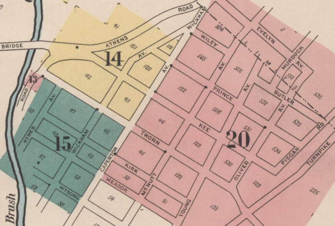
E: US 219's original routing through downtown Princeton followed Mercer Street through to its terminus at Virginian Railroad, then jogged one block north to the Princeton Overhead Bridge carrying the highway to East Princeton.
Some photorevised topographic maps (and one shoddy state map) show the highway routed along Kee Street north of Thorn; however, I'm confident this was in error. The Overhead Bridge was reconstructed to directly abut Thorn Street in 1924, and most WVSRC materials of the 1930s are consistent about showing this routing. Thorn Street also formed the only direct connection to WV 20 and 44 on Athens Road, and this was already in place along its present-day routing (labelled "Turnpike") by 1923.
![[US 460 map]](transpo/us460x-princeton.png)
The precise history of US 219's and 460's path through Princeton is a bit convoluted:
![[US 460 map]](transpo/us460-74wvdh.jpg)
(WVDH/AASHTO Application, 1974)
![[US 460 photo]](transpo/us460-princeton00.jpg)
F: This is a pretty good representation of what most of US 460 on Corridor Q looks like: Separated lanes of traffic, few curves, and wide open spaces. This is the view on the 1970s-era overpass over I-77, which was later reconstructed as a wider unified span. Visible in the distance are the distinctive pyramids of the West Virginia Tourist Information Center. (Photo by the author, 2000).
Back in the 1990s, I distinctly remember that WVDOT hoisted and waved the Canadian flag outside the Info Center as a gesture to welcome visitors from north of the border. There are no welcoming gestures at the centre now: Just a circle of military banners, which feels like the opposite of that.
![[US 460 photo]](transpo/us460-72bdt.jpg)
G: A glimpse of Corridor Q in its construction stages. The new four-lane alignment opened in phases between 1972 and 1978, with the pictured segment being the first to open. This photograph was taken at Divide Ridge facing west, and the scene is essentially the same today. (Bluefield Daily Telegraph, 1972)
![[US 460 photo]](transpo/us460-17nyttend.jpg)
(Photo by Nyttend, 2017; public domain)
H: After passing through West Virginia for 43 kilometres, US 460 finally emerges in Virginia once more, in the town of Glen Lyn...a place that quite literally consists of a coal-burning, filth-belching power plant with half a dozen houses scattered around it. The scene lends itself a quasi-dystopic vibe that looks lifted from a Pink Floyd album cover.
Thankfully the times are a-changing...even in the folds of Appalachia. After violating clean air regulations for decades while cleaner forms of energy undercut coal in the market, American Electric Power begrudgingly came to its senses and decommissioned Glen Lyn and ten other coal-fired plants in 2015...reducing the carbon footprint of the area by a far greater degree than any individual action could have done. Everyone's lungs (and lives) hearby rejoice!
![[US 219 photo]](transpo/us219ny25.jpg)
(Photo by the author, 2025)
The historical courses of US 460 and US 219 split just east of Glen Lyn in Rich Creek, Virginia. 219's north terminus is at Interstate 90, 861 kilometres north in Buffalo (or technically West Seneca), New York...a walkable distance from the Peace Bridge.
US 219 is actually one of two "straight-shot" highways which link Mercer County to Canada. US 52's course is even gap-free, continuing northwest from Bluefield with continuity to North Portal, Saskatchewan...although that highway's 2700-kilometre diagonal course would require considerably more travel time for West Virginia émigrés than US 219.
![[US 219]](transpo/us219fract.png)
CR 219/1 through CR 219/10 were numbered off eastly from Princeton to the Virginia state line as part of the original fractional number allocation in 1933, with higher-numbered roads being later additions. One number (219/5) was later reassigned to a completely different road.
| Road | Names | Start | Terminus | Length (km) | Notes |
|---|---|---|---|---|---|
| 219/1 | Old Oakvale Rd., E. Reynolds Ave. | WV 104 (former US 219) east of Princeton | CR 460/10 (former US 219) east of Princeton | 2 | Original 1930s assignment. Former alignment of US 219's predecessor road. |
| 219/2 | Greasy Ridge Rd. | US 460 (former 219) east of Princeton | CR 38/4 near Hardy | 6 | Original 1930s assignment. North terminus moved east due to construction of I-77. |
| 219/3 | Halls Ridge Rd. | US 460 (former 219) east of Princeton | CR 26 near Hatcher | 8 | Original 1930s assignment. West terminus moved north due to construction of Corridor Q. |
| 219/4 | Elmore School Rd. | CR 219/2 | dead end | 2 | Original 1930s assignment. Formerly connected to US 219; east stub now part of CR 38/4. |
| 219/5 (old) | Whites Crossing Rd. | US 460 | CR 219/3 | insignificant | Original 1930s assignment. Now CR 460/12 |
| 219/5 | Thorn St. | WV 20 (former US 219) at Oliver Ave., Princeton | WV 104 (former US 219), Princeton | insignificant | Former alignment of US 219 |
| 219/6 | Pigeon Creek Rd., Big Springs Branch Rd. | CR 460/6 (former US 219) near Oakvale | dead end | 5 | Original 1930s assignment. |
| 219/7 (old) | Whitts Rd. | US 460 (former 219) | CR 9/6 | 4 | Original 1930s assignment. Now part of CR 28/3. |
| 219/8 | Hales Gap Rd., Newton Rd. | CR 460/6 (former US 219) | CR 219/6 | 8 | Original 1930s assignment. Impassable? |
| 219/9 | Pigeon Creek Rd., Neal Chapel School Rd. | CR 219/8 | CR 219/8 | 6 | Original 1930s assignment. |
| 219/10 (old) | Adairs Run Rd. | US 460 (former 219) | CR 28 | insignificant | Original 1930s assignment. Now part of CR 28/5. |
| 219/11 (old) | Rogers St., Brick St., Stafford Dr. | US 20 (former 219), Princeton | US 19, Princeton (final terminus) | 3 | Added by 1946. Now part of WV 104. |
| 219/12 | Crotty St., Berkeley St., Wood Ave., S. Wickham Ave. | WV 104 (Rogers St., former 219/11), Princeton | WV 104 (Rogers St., former 219/11), Princeton | insignificant | Loop |
| 219/13 (old) | Locust St., Asphalt Rd., Wabash Rd. | WV 104 (Rogers St.), Princeton | dead end | insignificant | Now CR 31. |
| 219/14 | Fayette St. | CR 219/25, Princeton | CR 31, Princeton | insignificant | |
| 219/15 | Summers St. | CR 219/17, Princeton | CR 219/14, Princeton | insignificant | |
| 219/16 (old) | Roseland Ave. | WV 104 (Rogers St., former 219/11), Princeton | dead end | insignificant | Now a Princeton city street. |
| 219/17 | Monroe St. | CR 219/12, Princeton | dead end | insignificant | |
| 219/18 (old) | (unknown name) | WV 104 (Rogers St., former 219/11), Princeton | dead end | insignificant | Now a Princeton city street. |
| 219/19 (old) | Bee St. | WV 104 (Stafford Dr., former 219/11), Princeton | dead end | insignificant | Now a Princeton city street. |
| 219/20 | Planet Dr. | WV 104 (former US 219) east of Princeton | dead end | insignificant | Truncated by US 460 in 1978, leaving CR 27/10. |
| 219/21 (old) | Lazenby Ave. | WV 104 (Brick St., former 219/11), Princeton | 4th St., Princeton | insignificant | No longer numbered. |
| 219/22 | Tango Dr. | CR 219/1 east of Princeton | dead end | insignificant | |
| 219/23 | Springdale Ave. | WV 104 (former US 219) east of Princeton | CR 219/1 east of Princeton | insignificant | |
| 219/24 | Edgemont Dr. | WV 104 (former US 219) east of Princeton | CR 219/25, Princeton | insignificant | |
| 219/25 | Foster St. | CR 219/5, Princeton | dead end | insignificant | |
| 219/26 | Greenview Dr. | CR 460/16 east of Princeton | itself (loops) | insignificant | |
| 219/27 | (unknown) | ||||
| 219/28 | Turnpike Industrial Park Rd. | CR 219/3 east of Princeton | dead end | insignificant | Formerly part of CR 44/12. |
| 219/29 | Field St. | CR 460/16 east of Princeton | dead end | insignificant | |
| 219/30 | Pikeview Dr. | CR 219/1 east of Princeton | dead end | insignificant | |
| 219/31 | Hearn Ave. | CR 219/12, Princeton | dead end | insignificant | |
| 219/32 | Carter Dr. | CR 219/1 east of Princeton | CR 219/1 east of Princeton | insignificant | |
| 219/33 | Southview Dr. | CR 219/1 east of Princeton | dead end | insignificant | |
| 219/34 | Shumate Rd. | CR 219/6 | dead end | insignificant | |
| 219/35 | Oakwood Ln. | CR 219/1 east of Princeton | CR 219/36 | insignificant | |
| 219/36 | Coy Ave., Hedge St. | CR 219/1 east of Princeton | CR 460/10 (former US 219) east of Princeton | insignificant | |
| 219/37 | Southview Ct. | CR 219/33 east of Princeton | CR 219/33 east of Princeton | insignificant | |
| 219/38 | South Saunders Ave. | WV 104 (Rogers St.), Princeton | CR 31, Princeton | insignificant | Former alignment of CR 219/13 and CR 31. Never touched US 219. |
![[US 460]](transpo/us460fract.png)
"460" prefixed fractional roads first emerged in the 1970s, and several of the lowest numbers were assigned to former alignments of the highway itself.
| Road | Names | Start | Terminus | Length (km) | Notes | |
|---|---|---|---|---|---|---|
| 460/1 | Hilltop Dr. | US 460 east of Princeton | US 460 between Princeton and Oakvale | 5 | Former alignment of US 219 & 460, bypassed 1972. | |
| 460/2 | Hilltop Dr. | CR 460/1 east of Princeton | dead end | insignificant | Former alignment of US 219 & 460, bypassed 1972. | |
| 460/3 (old) | Goodwins Chapel Rd. | US 460 north of Oakvale | WV 112, Oakvale | 4 | Former alignment of US 219 & 460, bypassed 1972. Now CR 35. | |
| 460/4 (old) | Oakvale Rd. | WV 104 (former US 460) east of Princeton | dead end | insignificant | Former alignment of US 219 & 460, bypassed 1972. Now 460/10. | |
| 460/5 | Fountain Park Rd. | CR 460/1 (former US 460) | dead end | insignificant | Former alignment of US 219 & 460 | |
| 460/6 | Goodwins Chapel Rd., Kellysville Rd. | WV 112 near Oakvale | US 460 west of Glen Lyn | 6 | Former alignment of US 219 & 460, WV 12 | |
| 460/7 | Service Rd., Old Oakvale Rd. | US 460 east of Princeton | dead end | insignificant | Not actually part of the old Oakvale Road. | |
| 460/8 | Old Johnston Chapel Rd. | CR 460/1 (former US 460) | dead end | insignificant | Former stub of 219/3, bisected by the construction of Corridor Q in 1972. | |
| 460/9 | Winfrey Ln. | US 460 | dead end | insignificant | Missigned as 460/3. | |
| 460/10 | Oakvale Rd. | WV 104 east of Princeton | CR 460/7 east of Princeton | insignificant | Former alignment of US 219 & 460 | |
| 460/11 | (unknown) | |||||
| 460/12 | Whites Crossing Rd. | US 460 | CR 219/3 | insignificant | Formerly 219/5. Impassable? | |
| 460/13 | Whitlow Rd. | US 460 | dead end | insignificant | ||
| 460/14 | Browns Rd. | US 460 | dead end | insignificant | ||
| 460/15 | Stinson Rd. | US 460 east of Princeton | CR 219/1 east of Princeton | insignificant | ||
| 460/16 | Old Oakvale Rd. | CR 460/7 east of Princeton | CR 219/1 east of Princeton | insignificant | Former alignment of US 219's predecessor road | |
| 460/17 | Possum Hollow Rd. | US 460 | dead end | insignificant | ||
| 460/18 | Karens Way | CR 460/17 | dead end | insignificant | ||
| 460/19 | (unknown) | |||||
| 460/20 | Wallingford Rd. | CR 460/1 east of Princeton | CR 460/8 | insignificant | ||
| 460/21 | (unknown) | |||||
| 460/22 | E. Martin Dr. | US 460, Princeton | dead end | insignificant | ||
| 460/23 | Frontage Rd. | US 460 south of Princeton | US 460 south of Princeton | insignificant | Former alignment of US 19, 21, & 460, bypassed 1997. | |
| 460/24 | Frontage Rd. | US 460 south of Princeton | dead end | insignificant | Former alignment of US 19, 21, & 460, bypassed 1997. |
![[US 219 map]](transpo/us219x-2466usgs.jpg)
![[Home]](home.gif) The Network
The Network![[Back]](back.gif) Mercer County
Mercer County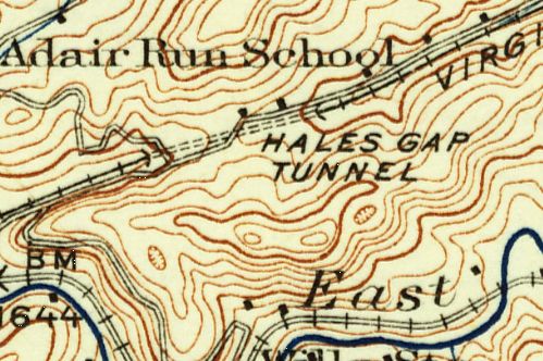