![[Hamilton, ON highway map]](transpo/rr200.png)
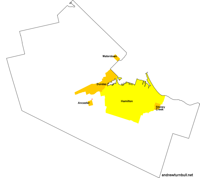
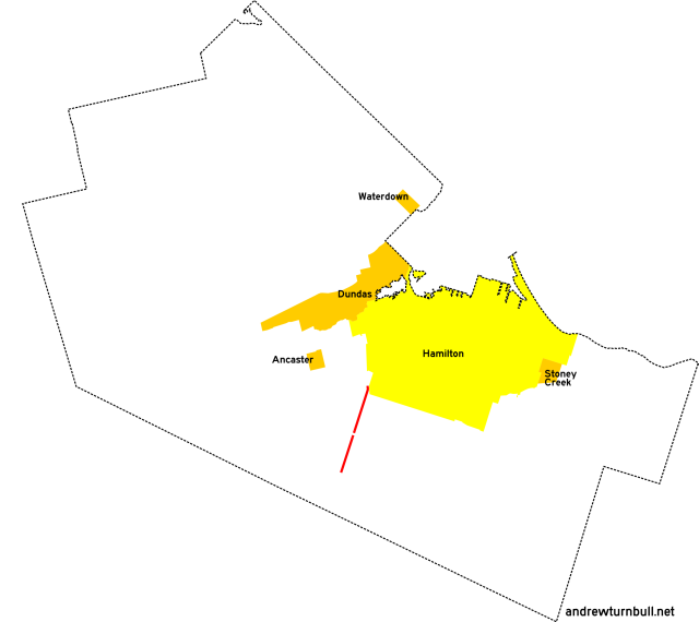
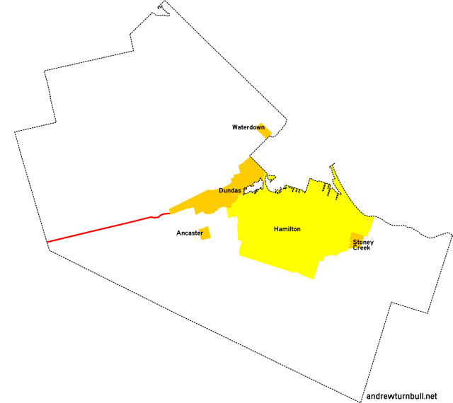
The Town of Ancaster consisted of both Ancaster Village, and the surrounding hitherto-unincorporated township.
| 202 | 203* | ||||||||
| 210 | 215* | 216 | 217 | ||||||
| 222 | 223 | ||||||||
| 232* | |||||||||
| 247 | 248 | ||||||||
| 253 | |||||||||
| 299* | |||||||||
= Based on pre-1979 regional road number
= Based on Ontario provincial highway number
= Random or sequential numbers
* = Continues across municipal boundary with a change of leading digit
| Highway | Map (click to enlarge) | Names | Start | Terminus | Length (km) |
|---|---|---|---|---|---|
RR 202 | |||||

|
|
Montgomery Dr. | Old Dundas Rd., Ancaster Village | Wilson St. (ON 2), Ancaster Village | insignificant |
|
Added in 1979; probably unnumbered before. At a mere 200 metres in length, this connecting stub between two parallel roads is irrefutably the shortest "highway" in Hamilton-Wentworth that ever existed. |
|||||
RR 203 | |||||
 |
|
Lynden Rd. Jerseyville Rd. Sunnyridge Rd. |
ON 99, Lynden (continues from RR 503) | Wilson St. (ON 2/53) west of Alberton | 9 |
|
Previously: RR 3. This highway's designation reverted to RR 3 on some late-period signage. |
|||||
RR 210 | |||||

|

|
Scenic Dr. | Hamilton city limits at Mohawk Rd. | Hamilton city limits near Lower Princess Falls | insignificant |
|
Previously: CR 10W, RR 10; with no changes or adjustments. |
|||||
RR 215 | |||||
|

|
Mohawk Rd. | Wilson St. (ON 2), Ancaster Village | Hamilton city limits east of Ancaster (continues as RR 115) | 4 |
|
Previously: RR 15. Adjustments: The original road was bisected in the 1990s by the Lincoln M. Alexander Parkway and its interchange with ON 403, leaving this highway discontinuous with a stub signed as Old Mohawk Road. |
|||||
RR 216 | |||||

|
|
Fiddlers Green Rd. | Jerseyville Rd., Ancaster Village | Carluke Rd. near Carluke | 8 |
|
Previously: RR 16. Lengthened slightly from that road's original incarnation. |
|||||
RR 217 | |||||

|

|
Jerseyville Rd. | Brant County line west of Jerseyville | Lynden Rd. west of Jerseyville | 2 |
|
Previously: CR 3 (spur), RR 17. Follows Concession Line 3. |
|||||
RR 222 | |||||

|
|
Trinity Rd. Sawmill Rd. Carluke Rd. |
Wilson St. (ON 2/53) west of Duff's Corners | Glancaster Rd. west of Mount Hope | 11 |
|
Previously: RR 22 The Sawmill Road portion followed the regional line. Succeeded by: RR 52 (north of Brant CR 22), RR 65 (east portion) |
|||||
RR 223 | |||||

|
|
Jerseyville Rd. | ON 52 south of Copetown | Wilson St. (ON 2), Ancaster Village | 5 |
|
Previously: RR 23. Follows Concession Line 3. |
|||||
RR 232 | |||||

|
|
Old Dundas Rd. | Dundas south town limits (continues from RR 332) | Wilson St. (ON 2), Ancaster Village | 3 |
|
Previously: RR 32. Strangely, the Old Ancaster-Dundas Road was numbered as a Regional Road for only a very brief time. RR 232 was added to the system in 1979, and had vanished from maps by 1982! |
|||||
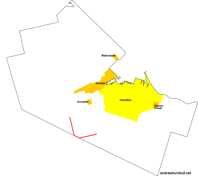
RR 247 | |||||
|

|
Wilson St. | Hamilton Dr., Duffs Corners | Hamilton city limits south of Dundas | 7 |
|
Concurrent with: ON 2. Previously: RR 47. "247" was an internal designation used to refer to the portion of the highway in Ancaster covered by municipal maintenance. It was never signed this way in the field. It would have been logical for this segment to be assigned the number 202; however, this was taken by another road. |
|||||
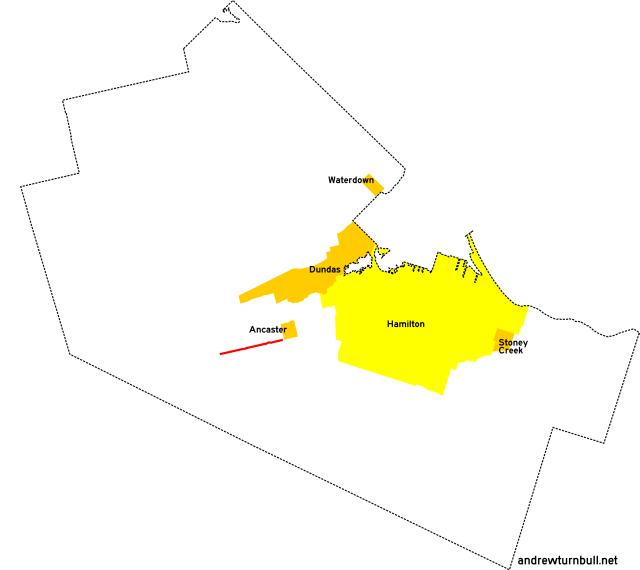
RR 248 | |||||
|

|
McNiven Rd. Southcote Rd. |
Mohawk Rd. east of Ancaster Village | ON 53 north of Southcote | 3 |
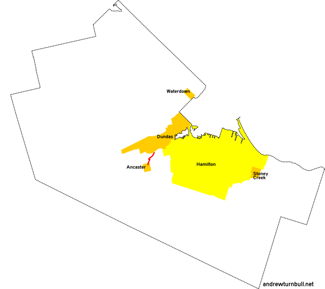
RR 253 | |||||
|
|
Glancaster Rd. | Garner Rd. (ON 53) west of Ryckman's Corners | Hamilton International Airport | 4 |
| Hamilton International Airport | Carluke Rd. east of Carluke | 3 | |||
|
Previously: RR 53. This road consisted of two segments running along the township line between Ancaster and Glanford (Glanbrook). It's probably a coincidence that it intersected a provincial highway with substantially the same number. Adjustments: This highway was discontinuous due to being bisected in 1960 by the 12-30 runway of the Hamilton International Airport. |
|||||
RR 299 | |||||

|
|
Governors Rd. | Brant County line west of Lynden | Binkley Rd. west of Dundas (continues as RR 399) | 15 |
|
Previously: ON 5B (1938-40), ON 99. Added in 1982. This highway ran along the base line separating Ancaster from the townships subsumed into Flamborough. Succeeded by: RR 99, which is still in commission today. |
|||||
![[Home]](home.gif) The Network
The Network![[Back]](back.gif) Hamilton
Hamilton![[Forward]](forward.gif) 300 series
300 series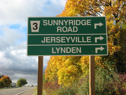