![[Early county road marker]](transpo/cr75-26dho.png)
![[Early county road marker]](transpo/cr75-27dho.png)
Early Ontario county road markers, from 1926 and 1927. (DHO)
County and regional roads make up the largest contingent of numbered highways in Ontario. Yet in spite of their long history (evidenced in the signs at right), these roads receive surprisingly little attention or documentation.
In stark contrast to a place like West Virginia where all county and primary roads are maintained by a central authority with consistent numbering and signage, Ontario is a discordant, chaotic free-for-all. Most of the counties, regions, and single-tier municipalities that sign these roads use a standardized "flowerpot" route marker design...but consistency ends there. There is no guarantee that any road will maintain the same number once it crosses a county or regional boundary, or will be signed with any number at all. Most municipalities are also very slapdash with signage, using non-regulatory fonts, illegibly-small numerals, inadequate placement, and other maladies.
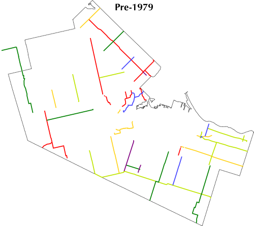
Hamilton-Wentworth's county and regional road system changed dramatically over the years. Originally, routes were assigned one- and two-digit numbers doled out in sequential order with no grid or geographical grouping, and county roads ended where Hamilton city limits began. No attempt was made to avoid duplication with provincial highways: CR 5, CR 6, CR 8, and CR 20 all existed, and CR 53 even connected to its provincial "twin!" Alternate spurs with letter suffixes were allowed, and numbers reached as high as 56 by 1967.
![[Hamilton-Wentworth route marker]](transpo/s-rr8old.png)
![[Hamilton-Wentworth route marker]](transpo/s-rr508.png)
![[Hamilton route marker]](transpo/s-rr65.png)
In 1974, Wentworth County was restructured into the Regional Municipality of Hamilton-Wentworth. Five years later, the now-regional road system was reorganized with three-digit numbers containing a leading numeral linked to the constituent city or town. A web of numbered roads were also introduced within Hamilton itself, although they were not signed or publicized.
Following full municipal consolidation in 2001, the regional road system of Hamilton was drastically simplified. Since all roads were now essentially city streets, names began to be emphasized for recordkeeping purposes and numbers dropped, except for a handful of arterials that reverted to two-digit numbers. All three-digit regional roads are officially defunct, although some signs and reminders of the old system continue to cling on...
All pages now have clickable image maps!
![[1979-2005]](transpo/rr-map3.png)
![[Home]](home.gif) The Network
The Network