![[Hamilton, ON highway map]](transpo/rr300.png)
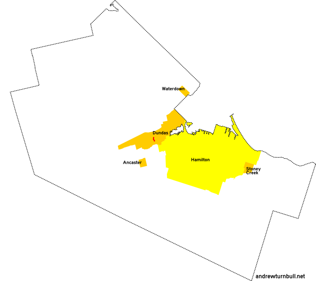
The Town of Dundas remained an autonomous entity during the time when this numbering scheme was in use.
| 305* | 308* | ||||||||
| 330 | 331 | 332* | |||||||
| 341* | 344 | ||||||||
| 354 | |||||||||
| 364 | |||||||||
| 399 | |||||||||
= Based on pre-1979 regional road number
= Based on Ontario provincial highway number
= Random or sequential numbers
* = Continues across municipal boundary with a change of leading digit
| Highway | Map (click to enlarge) | Names | Start | Terminus | Length (km) |
|---|---|---|---|---|---|
RR 305 | |||||

|

|
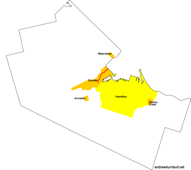
Sydenham Rd. | Dundas west town limits, along railway tracks (continues from RR 505) | King St. (ON 8), Dundas | 2 |
|
Although CR 5 existed by 1960, the road originally ended at the town limits, leaving the segment within Dundas unnumbered. |
|||||
RR 308 | |||||

|

|
King St. Main St. Osler Dr. |
Bond St., Dundas | Dundas east town limits (continues as RR 108) | 4 |
|
Concurrent with: ON 8. "308" was an internal designation used to refer to the portion of the highway in Dundas covered by municipal maintenance. It was never signed this way in the field. Succeeded by: RR 8 (King Street portion). |
|||||
RR 330 | |||||

|
|
Ogilvie St. | (1979) Governors Rd., Dundas | Old Ancaster Rd., Dundas | insignificant |
| (1984) King St. W., Dundas | Governors Rd., Dundas | insignificant | |||
|
Previously: RR 32; ON 5B, ON 99, RR 46 (1984 segment). Adjustments: Strangely, RR 330 seems to have completely shifted during its brief existence. Hamilton-Wentworth's 1979 regional road plan defines it as the south half of Ogilvie Street, with the north half left undesignated. 1984 maps depict it as the north half of Ogilvie, with the south half unnumbered! Still other maps highlight the 1979 segment, but leave it unnumbered. Governors Road serves as the dividing line between both incarnations. |
|||||
RR 331 | |||||

|

|
South St. | Old Ancaster Rd., Dundas | Osler Dr. (ON 8), Dundas | insignificant |
|
Added in 1979; probably unnumbered before. |
|||||
RR 332 | |||||

|

|
Old Ancaster Rd. | South St., Dundas | Dundas south town limits (continues as RR 232) | insignificant |
|
Previously: RR 32. Despite the age and gravity of Old Ancaster Road as one of Dundas' oldest roads, it carried this number for only a very brief time. RR 332 was added to the system in 1979, and had vanished from maps by 1982! |
|||||
RR 341 | |||||

|
|
King St. Cootes Dr. |
Main St. (ON 8), Dundas | Dundas east town limits (continues as RR 141) | 2 |
|
Previously: ON 102 (1947-1964), RR 41 (1973). Succeeded by: RR 8, which is still in commission today. |
|||||
RR 344 | |||||
|
|
York Rd. Olympic Dr. |
ON 6, north edge of Dundas | Cootes Dr., Dundas | 5 |
|
Previously: RR 44. Partially realigned from that road's original incarnation. |
|||||
RR 354 | |||||
|

|
York St. | Main St., Dundas | King St. (ON 8), Dundas | insignificant |
|
Previously: RR 44. |
|||||
RR 364 | |||||
|

|
York Rd. | Olympic Dr., Dundas | King St., Dundas | 2 |
RR 399 | |||||
|

|
Governors Rd. | (1979:) West of Bridlewood Dr., Dundas | Main St. (ON 8), Dundas | 2 |
| (1982:) Binkley Rd. west of Dundas (continues from RR 299) | Main St. (ON 8), Dundas | 6 | |||
|
Previously: ON 5B (1938-40), ON 99. RR 399 was originally an internal designation used to refer to the portion of ON 99 under municipal maintenance. After ON 99 was decommissioned in 1982, the "399" designation was expanded to encompass the entire highway in Dundas. It also began to be publicized on maps, and (probably!) signed in the field. Succeeded by: RR 99, which is still in commission today. |
|||||
![[Home]](home.gif) The Network
The Network![[Back]](back.gif) Hamilton
Hamilton![[Forward]](forward.gif) 400 series
400 series